Friday, May 16, 2025


                                             BLANDFORDIAN DELIGHTS                                                           

It looks down on you.  Wherever you are at Rocky Cape, it’s above you, taunting you to take up the challenge.  Every previous trip I’d resisted.  It is, after all, a long way up and much of the scenery below is worthy of your time as well.

                                                 
                                                        THE ROCKY BEACH

We’d done the North Cave, been down to the rocky beach, stayed at the wharf overnight, been to the lighthouse; there were few options left so, the decision was made.  It was only an hour return, piece of cake.

Well, except it was all uphill one way and it was over loose rocks, something I’d sworn not to walk on ever again.  However, they were nowhere as bad as Bishop and Clerk.  Poles at the ready, we set out up the hill, following the track that also takes you to Sisters Beach, if you want to do the three-hour thing.

Since it was decidedly overcast and rain was forecast, Mount Blandfordia seemed like the more sensible option.


In case you were wondering, the name comes from the earl of Blandford a couple of centuries ago and it’s a Christmas bell plant that grows only in Tasmania, a smaller version of the ones most people on the mainland are familiar with, and this is its western extremity.  I actually saw one but didn’t realise its importance and concentrated on photographing other flowers, all of which were so tiny as to almost escape notice.

                                                 The views are vast all over Rocky Cape

Some coastal heath, manuka, parson’s bands, fringe myrtle and one other all ended up in the photo storage.

When we reached the turnoff from the Sisters Beach trail I remember glancing up and hoping there would be amazing views over the hinterland when we reached the top and then pushed upwards with new inspiration.


                                                              It's all uphill from here!

At the top it’s rugged and difficult but doable as you scramble over the summit cluster of large rocks to get to the very top.  The views are expansive, to say the least.  You can see The Nut at Stanley from here and all the way to Wynyard on the other side.  Bass Strait forms a contrasting background to the foliage and ragged shoreline.  It’s something you can’t absorb quickly, but something you’ll never forget.


Later on, a walk along the beach where all the strata are tilted at around 70 degrees, and jagged as well, makes for more difficult walking, much harder than the hill in fact.  It’s the lichen covered rock I’m after, having only recently learned that there is no such thing as a singular lichen plant, it’s more a structural combination between an alga and a fungus.  The two link to make an extraordinarily strong pairing that can survive on the exterior exposed surfaces of rock and man-made walls and such.  The colours also make a lovely foreground for photographs!


It was along here we came across girls collecting driftwood, presumably for a fire that night.  It must have been somewhere else because you’re not allowed to camp overnight here.


Next stop was the South Cave, a tortuous short track up to where our indigenous population once camped, before they were wiped out.  It’s reasonably spacious but the walls, in line with everything else, are tilted over at that same geological angle that predominates here and has caused the odd outlines you see.  It’s also a bit deeper than it looks initially, but without a reliable torch I choose not to explore further.


We’d wandered around Rocky Cape for much of the day and left satisfied that we’d seen most of it, well, except for the underwater bits which are purported to rival the Great Barrier Reef in diversity and amazing wildlife.


We actually found an amazing skeleton along the shoreline of a dead fish with extraordinarily large eyes and weird long spikes all over its body, a sure sign it had once been in deep water because that’s where these bizarre things exist.

                                                         Simply strange and surreal

The water here is so clear and uncontaminated it must beckon experienced divers like a magnet to see the extraordinary creatures that exist offshore.  Sadly, I will never be among them but do envy some of the amazing scenes they witness.

That’s what Rocky Cape has to offer.


Sunday, March 30, 2025


                                                                    GOD’S PUNISHMENT


It’s Maria Island day, which involves being ready by 8.30 a.m., something we haven’t managed at all this trip, for the ferry departure.  Worrying about being ready and my dodgy right knee means little sleep is had because, for some unknown reason, I have decided to have a go at climbing Bishop and Clerk, a distinct outcrop of rock on the northern tip of the island that’s over 620 metres high.

Reading the reviews of others indicated it was probably out of my limits, but I figured if I factored in the push bike, there may be a faint hope.  “The climbing is relentless” one reviewer wrote and, apparently, at the end it gets a lot worse.

So, with much trepidation I headed out on the pushie after the ferry docked, hoping to beat all the walkers who would be trying the climb (turned out there were only six others).


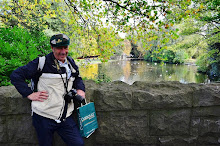
Maria is an enchanting place, free of unnatural predators and thus wildlife flourishes, wombats, echidnas, cape barren geese and native hens, not to mention all the roos, are all flourishing. As you head out, you’re apt to come across some of them.  I mean, where else in Australia can you find a nice furry wombat right beside the dusty trail trying to have a sleep?


It’s open country initially, with vast seascapes across the water to a couple of tiny islands just offshore.  As you swing around to face the distant outcrop the trail gets steep, very steep.  I’m resigned to using a granny gear and zig-zagging and still have to stop a couple of times before the top.  Then there’s a matching steep downhill before another similar energy-sapping ascent with a bench seat for respite about half-way.


After that it’s woodland, though the edge of the cliffs is quite close on the port side still and, on the other side of the trail is the most patterned eucalypt I’ve ever seen in my life. However, as the lady wrote, it’s “relentless” in terms of uphill, though the trail itself is good and easy to follow. 

I manage to get further up, stopping to catch my breath on occasions until, finally, I give up, dismount, and leave my bike and helmet behind.  I figure I’ve only got about 2 kms to go, how hard can it be?


Well, it’s alright and I’m moving freely until the trail has tree roots and a few rocks here and there and it gets just a little arduous.  Then it gets a little more steep, more rocky and more arduous.  That was the good bits because it’s then that you see the landslide rocks.  Nothing in my entire bushwalking life prepared me for this.  It’s a nightmare..


At some stage in the past masses of lumpy rocks have cascaded down the mountain and now, devoid of vegetation, you have to walk up it.  Still, I can see that just 200 metres up the trees start again.

Oh dear, there are only a couple of trees and then the nightmare starts again and the summit looks light years away, it’s so much higher.


Through another couple of trees and then onto a bigger slope, it really is relentless but, then it gets worse!  When you finally get just below the summit, many people don’t go any further because, frankly, it’s just plain scary.  You have to scale a couple of vertical rocks with faint footholds to actually get on the summit.  It is no place for the faint hearted. 


I have a couple of goes before I get enough confidence to throw the top half of my body on the slab and literally drag myself onto it.  How I’m going to get back down I have no idea.


As every reviewer suggests, it’s a spectacular place to be.  There’s an aura here that wraps itself around you and won’t let go.  Whether it’s viewing the lower nearby “Clerk” bit of the formation or gazing back 5-6 kilometers from whence you came, it’s all impressive.

There’s a split rock formation here that involves jumping from one to the other and risking serious injury or death if you make a mistake.  I move around a few but won’t go on the furthest one.  After all, slip and it’s nearly 2,000ft to the ocean.

Eventually, after eating my meagre lunch and emptying my water bottle, other climbers arrive, two men followed by a younger middle-aged German lady, all much more supple than I.  Photos are taken and we get chatting.  Apparently Mount Amos is more scary because it has a slippery granite slope; I remind myself never to go there.

Because one of the gents is comfortable wandering around the far rock I eventually give it a go.  It’s not as scary as I thought but I can understand why all three women (another two have just arrived) point blank won’t go there.

Then, if you thought coming up was bad, wait till you have to descend!  A change of underwear would be a requirement for some.  Going over the edge onto three uncertain steps has everyone worried and I’m glad I remembered my “go down backwards” policy because it makes it a lot more doable, but still scary.

My knees are in “complain” mode all the way back down the rocks.  “Will it ever end” keeps crossing my mind but, of course, it eventually does and the roughish part of the bushwalk commences.  A tree root here, a rock there, but at least I’m going down and the bike lies in wait somewhere further on.  That “somewhere further on” seems twice as far as when I was ascending, and my relief is palpable when the bright green helmet strapped to the frame comes into view.  Now it’s all downhill and much faster and easier.

When, on the top, the German lady and I had compared bike notes and she said she loved riding the mountains in Germany.  Imagine my surprise when I passed her walking.  She’d left her bike about two kilometres before mine and had hardly climbed anything.

I’d originally hoped to make the 2.30 ferry and rocked up with nearly half an hour to spare.  It had taken me around 5 hours to do something I’ll never do again or recommend to anyone.

Still, having done it, you get boasting rights (and a lot of pain for a few days afterwards!).

Labels: , , , ,

Friday, January 31, 2025


                                       MOKI DUGWAY – BLAME EDWARD!

"May your trails be crooked, winding, lonesome, dangerous, leading to the most amazing view."      Edward Abbey.

It rises before you.  The immediate thought is "Surely the road doesn't go up there?". There must be a turn somewhere, but no, it does, and it will be much to your surprise and everything that Edward Abbey suggested.

The thing is, vegetation is sparse in these arid lands, it's the rocks that rule and impress.  Oh my, do they impress.  Their majesty is undeniable.

The cliff is getting closer; no way is there a road there. 

I'm the only car anywhere in view.  My exploratory nature deigns that, from time to time, I'll end up in a situation like this.  Stuck out on some weird pathway, miles from any civilization, not confident of where I am; except, I’m in America and it has an ocean either side.  Stands to reason that I’ll know where I am sooner or later.

Then I’m at the base, signs warn of speed restrictions as the tar comes to an end but, since they’re in m.p.h., what do I know?  Just 5 m.p.h., whatever that means, and you know America’s never going to catch up with the rest of the world.


 There’s another factor that comes to light, it’s gravel.  Oh, my goodness.  From the parched valley I’m steadily rising, dust emanating from the tyres, especially at the switchbacks.  Halfway up I find it disturbing.  I later read it’s number one on the list of the scariest roads in Utah, “eminently dramatic” “death defying” and remote, seriously remote; no NRMA here, you’re on your own and at an average of 11 degrees ascent and I’ve just driven from the “Valley of the Gods”, perhaps I am unknowingly en route to heaven?

Another car on the route constitutes a serious rise in traffic numbers, but there aren’t any initially.

I’m fascinated, it’s simply the most breathtaking drive I’ve ever been on because you can see so far and how the way manages to get into those cliffs I find extraordinary.


The term “moki” is derived from the Spanish word “moqui,” which was used by explorers to describe the Pueblo Indians they encountered in this region, as well as the Ancestral Puebloan culture that once inhabited the area. “Dugway” is a term used to describe a roadway that has been carved into a hillside.  I can’t believe anyone could live in the area, it’s so barren.


Almost at the top there’s provision to pull over and gaze across the amazing landscape you’ve just driven through. After a few snaps I’m on my uncertain way again.  The plateau is flat and the driving easy until then, out from the scrub, two people emerge, both males and they’re thumbing for a lift…well, one of them is anyway.  Checking for any bulges in their attire, I pull up.  They’ve just finished a multi-day walk in some canyon or other and would like to get back to their car.  I can understand that, it’s the sort of thing I’d ask for and we’re soon on our way.  Well, one is, the other awaits his return, minding their packs and tents while he does.

Another reason I stopped was to find out just where I am.  According to my passenger, I’m going the wrong way is where I am.  At the intersection where I got onto the Dugway, I should have eased left.  Not to worry, just have to go down America’s most dangerous road to get back on track.  It’s that kind of day, that kind of trip, and I’m loving it!


This  aerial shot borrowed from the Utah government files

Labels: , , , ,


                                                       INDIAN HEAD - DAY TWO

It had been a tough day, I’d just returned and it was time to go to the toilet, of which there are three, mens and ladies plus a unisex.  As I walk past the ladies a middle-aged man is talking to someone inside. Transpires it’s his very young daughter and she’s crying; apparently she can’t get out as the lock is malfunctioning.  Unable to assist and it looked like the matter was in hand, I moved to the gents and sat down.

The father was reiterating that he would get help or some tools.  His daughter cried on.  Then he said he’d contact the manager, whose name was Gary.  He contacted him sooner than he thought; Gary was in the middle toilet taking the situation in and his clear voice indicated that he would soon organize assistance, just give him a minute.  Sitting down it all sounded like a script from a backyard comedy.

Gary was a character; he stays on site for free as he looks after any problem or notifies N.P.W.S. if it’s something he can’t handle.  The park has no fixed sites, no power, just toilets and cold showers.  Earlier in the day he’d enlightened me about the trail I was contemplating, the track to Diamond Head.  He was a veritable font of knowledge and two things he kept reiterating were that it was very steep and, it was wonderfully scenic. 

He looked a tad doubtful when I said I wanted to use the mountain bike, concerned about the steepness and the deteriorating state of the track.  Not to worry, I’ll give it a go.


The first part was easy, about half a kilometre up a moderate hill till there’s an open space.  This is where the hang gliders take off when the wind is from the right direction.  It’s also an unrestricted view south, down the seemingly endless beach all the way to unseen Crowdy Head beyond the horizon, a seascape so vast as to beggar the imagination.


I move on, past the sign that explains Kylie Tennant’s presence here in the naming of some things, such as the lookout.  She was an author of the earlier 20th century and loved the place, “League after league the headlands curve up the coast of the continent.  The white fingers of the sea play on them, each bluff giving out its unique note, making its own music.”


Now the track becomes problematic; either side has dried firm mud but there’s an eroded watercourse in the middle which makes cycling virtually impossible.  I dismount and start to walk.  There’s a sense of anticipation now as I move closer to the heights and the cliffs on the other side that confront the ocean.


Finally, I crest the bluff and it all looks promising as I swing left and savour the onshore wind, admiring the tiny native wildflowers that exist, if only barely, on the slopes and wondering what insects pollinate them, because the bees and other winged creatures have long ago been blown away by the persistent sea breezes.


I look down and there it is, the arch I’d noted yesterday during research.  Gary’s words come back to haunt me.  “It’s very steep”.  Indeed, it is, it’s no place for a bike there so I scramble on down on a trail where I would have loved my walking poles but, of course, they’re not to hand, literally.


It’s step by slow step; this is grade 4/5 stuff, not for the unfit or faint of heart.  The further down the more dramatic it becomes.  It’s one of the great seascapes of Australia.  A huge colourful cliff, a narrow bay awash with strange iridescent yellow/green rocks and then the arch on the left hand side being constantly tormented by the angry seas, at times so big they actually go over the top of the arch.  It’s mesmerizing.  You don’t know where to look, it takes over your brain, tormenting it with so many attractions in one spot.  This is the “scenic” of which Gary spoke.


I also realise I’ve been here before.  Before I was into photography, before I became a keen bushwalker, before I became a cyclist, about six decades had passed since I was last here.


Up or down, either is tough here and you won’t be making it without stopping regularly.  I spend about 20 minutes at the base, mesmerised by the grandeur of it all and so pleased I got to record it with favourable weather and seas, in one of their grander moods. High cirrus and big seas make a lovely combination, one suggesting calm and the other, mayhem.


Eventually I looked up and realised it was time to climb the rough narrow unmade track to the top, and it takes time, pausing to breathe in more oxygen than I was capable of while moving.  All the time the roar is taunting you from behind, trying to capture your attention still.


At the summit a couple have come along and I get them to take a picture of me, so few do I have.  They’re just about to head down so I pass on a few pointers before heading off….slowly.  There are bits of track here and there that are rideable, and just as many not.  Way below another group of rocks is defying the watery onslaught, foam splashing all over as the wash rears up and over.  It’s a timeless scene, yet time is the key.

I pull up at a bench seat where Gary sits to shoot the whales with his new camera.  He told me he takes a large umbrella and tripod up here these days so he doesn’t have to move much.  Judging by his profile, I can understand why.  The occasional beer is not unknown to him.


The next feature is a massive, semi-eroded pillar, only half detached, its deep brown colour contrasting with the blues and greens all around it.  It evokes power and mystery; it’s so unlike anything else here.  What geological event caused the situation?


Way down below, the lines of swells seem more organized than before and there’s an attempt by some hardy grasses to grow, buffeted by the natural elements as they are.  They’ve won over half the rock but other areas are denied to them.  The stalemate continues.

I clamber down the slope on a trail even less distinct that the previous one and it’s just as steep, just a few degrees off needing a rope.  One slip could really ruin your day!


Beneath the grass covered rocky outcrop there’s another arch in the making.  The salt water has made its way through a crevice and explodes every so often right through before thrashing around on the land side.  There’s a sort of disjointed harmony to it all.

Gary told me about the man he bought the camera off.  He goes down and lays on the grass for hours waiting for that timeless shot of a seabird coming back with prey attached to its claws.  He’s got everything from Brahminy kites to sea eagles.  Years of patience will do that for you.


I’m back on the “main” trail and climbing.  This is the bit where I really don’t want my bike.  It’s narrow, badly rutted, hard to get a foothold and you’re trying to manoeuvre a bike as well and it’s all uphill.  Easy going it’s not!  I can’t even see the top of the ascent because the trail rolls over near the summit.  The couple who took my photo have long since passed me and are well into the descent somewhere on the far side.

There’s more cliffs and Diamond Head just visible on the horizon but the route has moved away and now the vastness of the hinterland becomes the main feature.  Still, there’s more slope to get up until, finally, I’ve made it.

I spoke with an American couple just before the summit and they come from Washington State and we briefly exchanged notes as I said I’d been to Multnomah Falls.  He said the trail was good on the other side, the descent to Diamond Head.  I hoped he was right.

Transpires that he was and I’m ever so grateful because now, at last, there’s some justification for the mountain bike.  I get comfortable and swoop down the trail to Diamond Head, quickly passing the old couple and, in no time at all, I reach Diamond Head Caravan Park and I know it’s all road from here.


The only catch is I get more and more desperate to have a comfort stop.  Wind is pushing my belly in all directions and now it’s painful just sitting on the seat.  I’m forced to pull up and empty my stomach and feel fortunate there’s soft leaves at hand.  The relief is palpable and I now make my way to the real toilet, which is where the story came in.

Labels: , , , , , , , , , , , , ,

Wednesday, January 08, 2025

                                              UP WITH THE ANGELS

It gnawed at me.  I'd been denied the opportunity to join the ants on high last time I had been in America and, every so often, the image would pop into my mind; people atop a massive rock formation who I wanted to join, to see what it was like up there.  From down here, it looked awesome.

Now, a decade later, here I was, bus stop 5 (of 6) in Zion, America's fourth most popular national park, in the south of Utah, America's number one state for rock formations.  Previously, while on a coach tour, we'd been told to hop on the National Parks' bus (the only transport allowed), alight at stop one or two and walk back.  Somehow, in the back of my mind, curiousity reigned and, when I boarded the National Park's bus, I queried the driver as to the best plan of action.  He immediately said, "Get off at 6, walk back to 5 and then catch the bus back; which is exactly what I did, revelling in the stunning scenery as the puffs of dust rose at every footfall in the bottom of the awesome canyon and feeling sorry for the rest of our tour group who hadn't seen what I'd just viewed.


I reflect, as I write, at how fortunate I was to go when I did because, one year later, the only way you could get on the slope was to take part in a lottery, a system used elsewhere in the States for popular places that can't handle excessive crowds.  In other places they might get hundreds of people who turn up on a day with only 10 places allocated; it's that tough.

Research indicated that the ridge was labelled Angel's Landing and it was one of America's top ten day walks on every site I visited, mostly in the top three.  It was also potentially dangerous.  If you fall, that's it.  Finito.  There's no coming back when you drop over the edge up there.  It's not a place for the faint hearted, as I would find out in an hour or so.

As I alighted in the early hours, there were a couple of other hikers who joined me and we'd been warned to go to the conveniently placed toilet before we headed off.  It was sage advice.

                                             Angels Landing dead ahead

By the time I was ready, I was alone, a situation I'm used to after decades of walking and I lit out across the stream with the title of Virgin River, a tributary of the famous Colorado.  You're immediately aware of your surrounds, just how overpowering they are.  In every direction, the awe of giant sandstone cliffs imposes itself upon your psyche. Even when your head is down there's an awareness that something big is out there.

The smooth level path soon starts to rise; it's well made and well used.  Rain is but an occasional problem here and the soft gravel path is a delight to walk on and it starts to ascend, ascend up to where it is cut into a sheer cliff and it becomes more noticeable that you're rising. Numerous switchbacks later and a lot of climbing there's a 90 degree turn and you move into the aptly named "Refrigerator Canyon".  Light rarely ventures here and it's clear that it has the potential to get seriously cold, surrounded as it is by towering walls but we're heading away from the main chasm into another world.

                                                         Last stop before Refrigerator Canyon

Still, we're ascending until a U-turn, then there's Walter's Wiggles, 21 switchbacks named after Walter Ruesch, Zion National Park’s first superintendent.  This is serious steep and only the seriously fit go up this section without stopping for a breather before reaching the flat open Scouts Lookout where everyone pauses.  It is here that decisions have to be made.  To go, or not to go.


I sat down and pulled my drink bottle out while I contemplated the way ahead.  To be sure, it was narrow; scary narrow.  Doubts crept into various quarters of my brain and started to infect it.  On the other hand I reflected that I had waited 10 years for this opportunity, maybe if I gave it a go?  There were chains en route somewhere, right?  

                                              It's no laughing matter! The ridge is behind me

After about a quarter of an hour I decided to go a little way further and crept tentatively forward.  The closer I got the less scary it seemed.  I reasoned, from previous excursions, that, once you got into something, you tended to focus and some of the fear went away, leaving only mild apprehension.  That's where I found myself now, slowly on the ascent, firm grip on the solid chain and thinking it wasn't so bad.  Still, at last count, an estimated (depending on which site you go to) around 16 people have gone over around here, a point from where there's only one outcome.

One thing you can't ignore is just how spectacular it is now.  The words dramatic, sensational and awe-inspiring frequently surfaced in my conscious.  It was hard to know where to look next and then it started to ascend again.  One foot at a time, hang onto the chain, be prepared for any little slip, steady as she goes.  For the faint hearted this is the crunch point.  There's a 1,400 ft drop there, there's no safety rail.  Depending on what site you go to, 16 people at least have gone over the side.


Fortunately, you have to focus so much on your next step, it distracts you from other scenarios.

Then the trail crosses to the other side of this narrow ridge called Hogs Back and a steep incline, slightly off-camber, now has to be negotiated.  This was the scariest bit for mine but you are so focused on where you are going you don't think of anything else.  Besides, your goal is now just a few hundred metres away at 1,785 metres above sea level

An occasional tree has found root where grains have gathered in crevices and they make a welcome change in the landscape.

After scaling a steep section I'm nearly there and I make the mistake of looking back.  Frankly, it's downright scary.  I can't believe I just scaled the oh-so-narrow ridge I'm looking back on.  What was I thinking!


Back on the job, it's just over the length of a footy field to the goal, pardon the pun.  Here, people are savouring the moment.  A group of young Americans who'd passed me earlier come over to give me high fives; they're so impressed an Aussie in his mid 70's has made the climb.

One of their number was missing.  He's sitting, legs astride, on the very edge of a narrow precipice.  They explain he's a mountain climber and that's what they do, even though it's freaking out just about everyone else.


It's such a broad platform when you get there that there's ample room for everyone and people are clearly happy they've made the effort.  I have to say that, of all the walks I've ever done, this had one of the greatest rewards.  It takes a while before you realise there's one more thing left to do - you have to go down the same route and here, and I can't stress this enough, it pays to go down backwards, like sailors are taught on ships.  It is so much safer and quicker you'll wonder why you never found out before.


However, it's still a long way back but you feel a lot more confident and once you reach the Scouts Lookout it's nice broad path on the return.  I'm amazed at how busy it's become though, so glad I got there early as I'd advise anyone else.  You can do it more quickly, but allow four hours.

Labels: , , , ,