Friday, January 31, 2025


                                                       INDIAN HEAD - DAY TWO

It had been a tough day, I’d just returned and it was time to go to the toilet, of which there are three, mens and ladies plus a unisex.  As I walk past the ladies a middle-aged man is talking to someone inside. Transpires it’s his very young daughter and she’s crying; apparently she can’t get out as the lock is malfunctioning.  Unable to assist and it looked like the matter was in hand, I moved to the gents and sat down.

The father was reiterating that he would get help or some tools.  His daughter cried on.  Then he said he’d contact the manager, whose name was Gary.  He contacted him sooner than he thought; Gary was in the middle toilet taking the situation in and his clear voice indicated that he would soon organize assistance, just give him a minute.  Sitting down it all sounded like a script from a backyard comedy.

Gary was a character; he stays on site for free as he looks after any problem or notifies N.P.W.S. if it’s something he can’t handle.  The park has no fixed sites, no power, just toilets and cold showers.  Earlier in the day he’d enlightened me about the trail I was contemplating, the track to Diamond Head.  He was a veritable font of knowledge and two things he kept reiterating were that it was very steep and, it was wonderfully scenic. 

He looked a tad doubtful when I said I wanted to use the mountain bike, concerned about the steepness and the deteriorating state of the track.  Not to worry, I’ll give it a go.


The first part was easy, about half a kilometre up a moderate hill till there’s an open space.  This is where the hang gliders take off when the wind is from the right direction.  It’s also an unrestricted view south, down the seemingly endless beach all the way to unseen Crowdy Head beyond the horizon, a seascape so vast as to beggar the imagination.


I move on, past the sign that explains Kylie Tennant’s presence here in the naming of some things, such as the lookout.  She was an author of the earlier 20th century and loved the place, “League after league the headlands curve up the coast of the continent.  The white fingers of the sea play on them, each bluff giving out its unique note, making its own music.”


Now the track becomes problematic; either side has dried firm mud but there’s an eroded watercourse in the middle which makes cycling virtually impossible.  I dismount and start to walk.  There’s a sense of anticipation now as I move closer to the heights and the cliffs on the other side that confront the ocean.


Finally, I crest the bluff and it all looks promising as I swing left and savour the onshore wind, admiring the tiny native wildflowers that exist, if only barely, on the slopes and wondering what insects pollinate them, because the bees and other winged creatures have long ago been blown away by the persistent sea breezes.


I look down and there it is, the arch I’d noted yesterday during research.  Gary’s words come back to haunt me.  “It’s very steep”.  Indeed, it is, it’s no place for a bike there so I scramble on down on a trail where I would have loved my walking poles but, of course, they’re not to hand, literally.


It’s step by slow step; this is grade 4/5 stuff, not for the unfit or faint of heart.  The further down the more dramatic it becomes.  It’s one of the great seascapes of Australia.  A huge colourful cliff, a narrow bay awash with strange iridescent yellow/green rocks and then the arch on the left hand side being constantly tormented by the angry seas, at times so big they actually go over the top of the arch.  It’s mesmerizing.  You don’t know where to look, it takes over your brain, tormenting it with so many attractions in one spot.  This is the “scenic” of which Gary spoke.


I also realise I’ve been here before.  Before I was into photography, before I became a keen bushwalker, before I became a cyclist, about six decades had passed since I was last here.
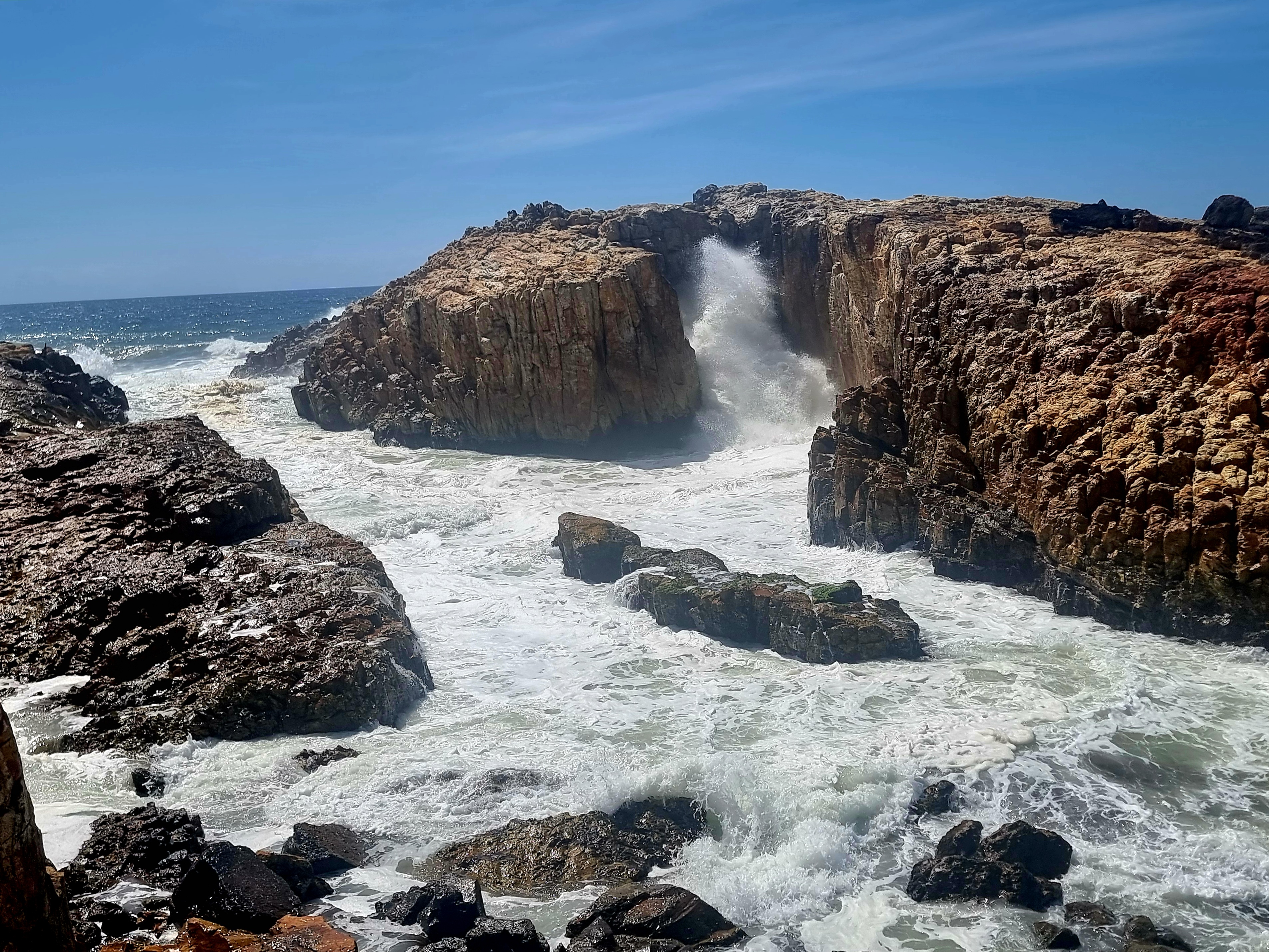

Up or down, either is tough here and you won’t be making it without stopping regularly.  I spend about 20 minutes at the base, mesmerised by the grandeur of it all and so pleased I got to record it with favourable weather and seas, in one of their grander moods. High cirrus and big seas make a lovely combination, one suggesting calm and the other, mayhem.


Eventually I looked up and realised it was time to climb the rough narrow unmade track to the top, and it takes time, pausing to breathe in more oxygen than I was capable of while moving.  All the time the roar is taunting you from behind, trying to capture your attention still.


At the summit a couple have come along and I get them to take a picture of me, so few do I have.  They’re just about to head down so I pass on a few pointers before heading off….slowly.  There are bits of track here and there that are rideable, and just as many not.  Way below another group of rocks is defying the watery onslaught, foam splashing all over as the wash rears up and over.  It’s a timeless scene, yet time is the key.

I pull up at a bench seat where Gary sits to shoot the whales with his new camera.  He told me he takes a large umbrella and tripod up here these days so he doesn’t have to move much.  Judging by his profile, I can understand why.  The occasional beer is not unknown to him.


The next feature is a massive, semi-eroded pillar, only half detached, its deep brown colour contrasting with the blues and greens all around it.  It evokes power and mystery; it’s so unlike anything else here.  What geological event caused the situation?


Way down below, the lines of swells seem more organized than before and there’s an attempt by some hardy grasses to grow, buffeted by the natural elements as they are.  They’ve won over half the rock but other areas are denied to them.  The stalemate continues.

I clamber down the slope on a trail even less distinct that the previous one and it’s just as steep, just a few degrees off needing a rope.  One slip could really ruin your day!


Beneath the grass covered rocky outcrop there’s another arch in the making.  The salt water has made its way through a crevice and explodes every so often right through before thrashing around on the land side.  There’s a sort of disjointed harmony to it all.

Gary told me about the man he bought the camera off.  He goes down and lays on the grass for hours waiting for that timeless shot of a seabird coming back with prey attached to its claws.  He’s got everything from Brahminy kites to sea eagles.  Years of patience will do that for you.


I’m back on the “main” trail and climbing.  This is the bit where I really don’t want my bike.  It’s narrow, badly rutted, hard to get a foothold and you’re trying to manoeuvre a bike as well and it’s all uphill.  Easy going it’s not!  I can’t even see the top of the ascent because the trail rolls over near the summit.  The couple who took my photo have long since passed me and are well into the descent somewhere on the far side.

There’s more cliffs and Diamond Head just visible on the horizon but the route has moved away and now the vastness of the hinterland becomes the main feature.  Still, there’s more slope to get up until, finally, I’ve made it.

I spoke with an American couple just before the summit and they come from Washington State and we briefly exchanged notes as I said I’d been to Multnomah Falls.  He said the trail was good on the other side, the descent to Diamond Head.  I hoped he was right.

Transpires that he was and I’m ever so grateful because now, at last, there’s some justification for the mountain bike.  I get comfortable and swoop down the trail to Diamond Head, quickly passing the old couple and, in no time at all, I reach Diamond Head Caravan Park and I know it’s all road from here.


The only catch is I get more and more desperate to have a comfort stop.  Wind is pushing my belly in all directions and now it’s painful just sitting on the seat.  I’m forced to pull up and empty my stomach and feel fortunate there’s soft leaves at hand.  The relief is palpable and I now make my way to the real toilet, which is where the story came in.

Labels: , , , , , , , , , , , , ,

Wednesday, September 04, 2024


A CROWNING ACHIEVEMENT

The red light is as a portent of disaster, its probing rays straining through the morning fog and sparkling on the ice of the frosty ground as if a harbinger of doom. Ice also covers half the windscreen as I reflect on the previous day’s events.


The road to Tarana (out from Lithgow) is the pothole centre of the universe. If you had kids in the back you could offer a prize to the first one to spot a thousand potholes and one of them would surely claim it. For some of the route you’ll be on Sodwall Road and you’ll understand the “Sod” bit, but not the “well”. I had arrived at Tarana in the dark, looking forward to a hot meal at the local one storey pub after viewing tempting pictures of meals on line.


There were two smokers outside. You could tell they were because why else would you choose to suffer in minus two degrees when inside was much more pleasant….and warm. The elder of the two could obviously trace his drinking back, not in years, but decades. The younger one started chatting to me.

Why was I here? A meal, preferably hot. “I don’t think cook is on tonight”, he mused. “Oh shit”, I thought, nearly an hour of that dreadful road for nought.

I checked inside anyway. The pub was full of characters, about 14 of them all up, one fiddling with a musical instrument. As they became silent, I became the instant focus of attention.

“Do you have hot meals?” “I’m sorry, not Monday or Tuesday”, replied the barmaid. “What about a hot drink?” I probed. No joy there either. I turned and slumped out, only to be confronted by the two outside wanting to know what had brought me to Tarana. I mentioned Evans Crown and was immediately given detailed instructions as to how to get there. Turns out I’d already gone past the turnoff about 5 kms ago.

Then they wanted to know about where I would stay and suggested just down the road near the fire station. When food and drink came up they commenced a rant on mulled wine. “That’ll warm you up,” the elder one enthusiastically remarked. I didn’t have the heart to tell him I was a teetotaller, I simply started moving away.

From where I parked you could see a bright red light adjacent to the railway, though I wasn’t worried about trains, I’d lived next the main Sydney-Newcastle line for the first 21 years of my life. What noise?


Now it was morning and I had to move which is a bit difficult when it’s comfortably below freezing but I managed and was soon swerving to avoid potholes again before turning off and finding a nice level carpark where I should have spent last night.


There’s a very helpful information board at the start of the walk (read “climb”). It indicated that an hour and a half should see you done. I budgeted for 2 ½ and set off up the well laid steps. There’s nothing to see except forest, some bush birds and an odd kangaroo for the first 20 minutes or so. Then you espy the occasional rock peeping through the trees on high. Granite worn in interesting shapes.

At the top a T-intersection sign indicates unmarked trails to the right and left. Since the vast majority of rocks were left, that’s where I, and many others before, trekked off to. It had shades of Girraween in Queensland about but these were more colourful and two were massive.


Probing along the narrow worn path I paused regularly for pics, so much was the variation and so many the angles. You’re not quite sure whether to take some leads or not but they all proved fruitful in the end and I was ecstatic with the results. Well over half an hour passed by before I got back to the intersection and took the other direction.


Here, there are occasional spots where the faintest of trails is visible but, basically, you’re on your own. Valley views were promised but, after about 20 minutes I hadn’t found any until I opted for a new direction. Moments later I came out upon a clear section featuring small rock outcrops laden with moss and lichen. The silence, as they say, was deafening. I found a comfy spot, sat down, and immersed myself in the panorama.


For accompaniment the cows way down on the farms decided it would be a good time to moo and, during the whole 15 minutes I sat there, they never shut up! The mist was slowly dissipating but the remnants looked lovely and added calm to the scene. By the time I left it was clear.


I got misplaced on the way back. Knew where I was heading but, since there are no paths on this less travelled side, it’s problematic which direction you should take. Thus I stumbled on another outcrop of granite before finding a way around it and eventually reaching the T-intersection once more.


The three hour mark was already broached as I started the descent, diverting to a significant outcrop before reaching the bottom, just as a group of noisy schoolchildren (are there any other types?) commenced the ascent on their day’s outing, probably not realising how lucky they are to be so close to a significant natural attraction and use it during school time.

After a well-earned cup of tea it was time to hit (literally) the potholes again!

Labels: , , , , , , ,

Tuesday, May 15, 2018

Blue Mountains N.S.W. Hanging Rock


JUST HANGING FOR IT
I’d decided to take the mountain bike.  This would be its first trip away and I planned to use it.  My main goal was Hanging Rock, a dazzling precipice somewhere in the Blue Mountains that I’d seen pictures of but never really chased.  Then someone posted a dawn shot on Facebook and I was truly hooked this time.  I queried as to how to get to the place and received a reply.  Now it was written in ink.
There’s a trail by the name of Burramoko, off the end of Ridgeway Road, which leads you to Baltzer Lookout.  From here you can get shots of Hanging Rock.  I determined that I would try for a dawn rendezvous but that’s not always as easy as it seems.
After setting up at Coolah I’d been nearly a week in the wilderness and loving every minute of it but Hanging Rock would make the trip truly worthwhile.  It kept dragging me further ahead of schedule than I’d originally intended until I arrived a full day early and decided to try for a sunset ride just to check everything out.
                                        
The lady at the National Parks office at Blackheath had been very helpful, plying me with maps and relevant information to the point where I wasn’t sure which one to consult next but it was photocopied mud map that was the key so I sought out Ridgewell Road and travelled to the first locked gate.  It was here, I had been informed, that you could park your vehicle but, when I arrived, I was so glad it was late and a week day because your odds of getting a park would be zero on weekends and holidays.  There’s a sum total of about 6 spots and only two where a motorhome would fit.  I was lucky.
The map said it was 1 ½ kms to the second locked gate and then a further 4 kms to Baltzer.  I was so glad I’d brought the bike.  I set out without glasses because the light was getting poorer by the minute and regretted it soon after when clusters of insects smacked me in the face and a couple got under my eyelids.  It was a real roller coaster ride with erosion humps everywhere making the downhills a bit thrilling but the real excitement was further on.
                                        
I reached Baltzer and parked the bike; you have to walk the last 200 metres.  It’s only then that you get a sense of just how epic this spot is.  There are no fences, just vertiginous drops into the abyss of Grose Valley.  Your sense of balance becomes instantly heightened; the slightest breeze becomes cause for alarm as the ridge narrows to its ultimate conclusion.  I couldn’t see Hanging Rock initially and looked in vain for the tell-tale overhang before finally figuring that photographing that iconic view involved going left down a trail that I had no wish to try now the sun had actually vanished from sight; so I retired from the scene and pencilled in the morrow.
As ever, wanting to get up without an alarm means little sleep will be had and only about four hours maximum was had in fits and starts before 5.30 arrived and it was suddenly panic stations because I knew I wanted the right light, nothing’s quite like the golden hour.  Spurred on by the raucous cry of a lone currawong I frantically got my riding gear on and headed out.  Flecked between the woodland vegetation a brilliant smoky red sun indicated its presence, tormenting me with colours I knew would be gone by the time I reached the lookout.
However, it was the bush track I had to concentrate on, especially the sandy bits and the erratic downhills.  I made good time and worked out that after leaving the bike I had to drop off left of Baltzer to get the shot that every other snapper worthy of the name already had.  But my, how steep was the track!  In a word, “very”.  I hesitated here and there because there was only a rutted trail beside the canyon wall, one slip and you could appear in the obituary columns next week.
The sought after scene came into play at last as I neared the bottom and passed three bolts to which rock climbers could fix their gear.  I knew already why I didn’t go rock climbing, this merely served to confirm that view.
                                                  
Being close to Hanging Rock makes you even more in awe of how geology works.  This protrusion, that will one day collapse (never with me on it!), is epic in scale and deliverance and, once you’re there, it’s easy to understand why people come here despite the safety hazards.  Somehow the other distant cliffs pale into insignificance beside this wonder of abstract art.  It took me some time before I decided to leave but I was secure in the knowledge that I had, at last, viewed and recorded this iconic platform.
                                       
The road back was almost lost in reflection except that the wildflowers had been kissed by old sol at shallow angles and their colours shone brilliantly.  It’s not always that planned days work out as you’d hoped, but this had exceeded my expectations.

Labels: , , , , , , , , ,