Thursday, April 18, 2019

A FISHER LURING MEN


I’d seen them from a distance over a decade ago.  Those upright bastions in the distance defying me to go and have a look at them.  Now I had time, but first I’d pencilled in Castleton Tower and The Rectory; two high rise pillars somewhere on the La Sal Loop Road.
                                     
GPS didn’t like the towers but gleefully accepted the loop road.  I headed south out of town for about 10 miles before it told me to turn off and it wove its way gently towards the mountains.  Obviously it will turn left and go follow the river or such at the base of the mountain.  No dummy, the mountains are named La Sal, just like the road, and you’re going up there.  It’s also a 50 mile (around 80 ks) road and you’re at the wrong end of it to see the tower.

So, up it went, climbing, climbing until I’m in the snow yet again, eyeing off panoramic views over Moab and beyond.  Understandably, there’s not a lot of vehicular traffic so I can stop frequently, often in the middle of the road, without worries.  At one point I find myself pulling over beside two carloads of young adventurers who’ve spent the night up here.  We quickly fall into chatting and one of them rushes over to the car and offers me some agate and mentions there’s lots of it nearby.  I add I’ll have weight problems at the airport so just take a small piece.

All I’d really pulled up for was a pool of water beside their cars in order to get some reflection shots because it’s mostly snow and, at one stage, I try and walk across some to get an angle and I’m suddenly up to knees in it.  Knew I should’ve brought those snow shoes!  It’s a lovely drive, I’m so pleased I found this meandering scenic byway where way below a long stark ridge juts hundreds of metres into the air.  It’s the boundary for Castle Valley where I’m headed.

Before the road takes its inevitable descent I can see the tower I’m aiming for way in the distance, constantly thereafter offering different angles, posing like a tempting model.  Before it is the massive Adobe Mesa, beside it The Rector and behind is Parriott Mesa, another great lump that apparently you can climb but it’s done rarely.

In time I stumble on the carpark for the tower.  I use “stumble” advisedly because there’s no sign as, around these parts, it’s one of the lesser attractions.  Again, some young folk have camped here overnight in flimsy one-man, or woman as it turns out, tents. 
Grabbing my phone I head off.  Though it’s not very long (where I go) the trail follows a dried-up watercourse and at two points it’s quite tricky clambering over drops about two metres high.  One takes me a couple of minutes to negotiate, wondering if, indeed, I can get up there and if it’s worthwhile, but after about ten minutes the scene opens up with both peaks impressively standing out and I do a U-turn to ascend a prominence that’s beside me.


It leads to a genuine 360 degree panorama of Castle Valley and you can see a thin trail leading to the base of Castleton Tower where the crazy climbers go.  I have no need to perform such deeds but I note there’s about four younger people edging their way up the steep trail.  It’s a massive base that’s been torn from the rock over millennia but your eye is drawn to the heights.
                                    
Then I edge my way back down and it’s off to Fisher Towers, my main goal for the day.  It’s about another 20 kilometres and, as I draw nearer to the turnoff, it’s clear I won’t be the only one there, though when I reach the carpark there’s only a couple of dozen vehicles, small potatoes by the numbers at Arches NP.

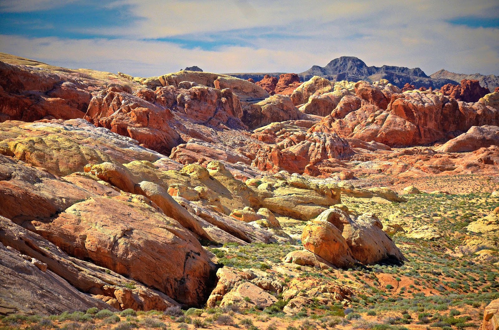
Even from the carpark this place is impressive.  Dramatic shafts of surprisingly stable Permian Cutler sandstone (290 million years old) topped with Triassic era Moenkopi sediments (240 million years) leave me gasping in awe, even more so when I head off in the wrong direction (three trails, no sign is my excuse) and end up in a small canyon.  The reward is a couple of unusual shots but I’m soon back heading in the right direction of this 7 km out and back hike.

Immediately I come across people pointing at one of the towers, the ever-popular (with climbers) Ancient Art Tower with the squiggly bit on the top.  Sure enough, there’s athletes up there near the summit.  Talk is that you’ll find someone up there most days.  They also have names for all the other peaks, like Echo, Cottontail and Titan.  Not sure where climbers dig them up!

Up close and personal these formations are beyond impressive; they dominate you in a way few other rocks I’ve ever walked beside do.  They are SO overpowering and the track meanders initially in the wash and then rises to the bases where it follows them around.

As you curve past one bend the wind if ferocious; starting on the opposite side and accelerating around the U-shape until it hits you at something like 90 kph.  It’s all I can do to hold onto my hat, protect my eyes and try and keep dirt out of my mouth.  Luckily I don’t have to worry about my camera because I’ve only brought the phone.
After that buffeting it eases the further you move and around the next corner there’s a short ladder you have to climb down before getting on top of another watercourse and rounding the next monolith, which is pretty close to where it all ends.


On the return leg I pay more attention to the mushroom shaped rocks.  These are harder slabs that have fallen from way above aeons ago and then the softer soil has eroded beneath them.  Rarely have I been made to feel so puny as I have beside this outcrop and, for me, it’s better than anything Arches has to offer.
                                     
I’ve teamed up with a young man named Corby and we swap traveller’s tales all the way back, making for a pleasant interlude.  It’s so nice to chat with someone while you’re walking along, sometimes you simply forget just how good it really is.                                 

Arches National Park


                                                    YES VIRGINIA THERE IS AN ARCH (OR TWO)
Arches National Park is an American icon, and rightly so.  In this one park alone it is claimed there are over 2,000 such features, more than anywhere else in the world.  I’d come here to see more than I did last time, a grand total of three and, on the day of my arrival I scooted up and nabbed another, Double Arch, which is a ball shaped hole in the rock with two huge gaps up the top.  I’d managed to climb into that and have my picture taken, along with about 10 other tourists at varying intervals.

Now, it was three days later and I hadn’t seen any more and I was off tomorrow.  Time to make some sort of effort.  In order to capture the best light I left in the dark and reached a spot where a feature called Balancing Rock stood.  It was there I pulled up because of the amount of other vehicles coming in, and I knew where most of them were headed, because Delicate Arch is the one most people want for a shot of the sun coming up behind an arch

.
So I sat there in the car while several others passed and, when the dark started to become light, stepped outside of the car.  It was about then that I realised my flannelette shirt and windcheater were inadequate for warmth.  The bracing wind took the short route and my exposed parts were freezing.  Trying to stay focused on the task at hand wasn’t easy and, having no idea of how the sun would actually strike the features kept my mind alive to possibilities. 
The first rays kissed the peaks and it was time to move.  The thin band of cloud offered little in the way of assistance in colouring the sky so it was time to concentrate on the rock formations and wait for the sun to bless some of the walls.  
                                
Soon there’s a curved wall with brightness on its upper parts and I make for that and spend probably nearly half an hour wandering around its precinct.  To be honest, I’ve never seen shots of this particular unnamed outcrop and the fact that there are no footmarks indicates that it’s well down in the pecking order of chosen photographic subjects.  Still, there’s no-one else here fighting for an angle.

Eventually I’ve worked the dawn here long enough and head up towards Devils Garden, the end of the road, but I never quite make it because I can see numerous opportunities en route for something unique, ever my goal.  The light is almost perfect and every venue delivers so that by the time I reach the Devils Garden loop I can’t be bothered stopping and head back to base once more.  Still, I did get to see Skyline Arch at one of the stops, that’s one more.

Afternoon rolls around and it’s time to make one last effort, probably at Landscape Arch, even though Delicate Arch is the one most pictured and I’d intended to see it but I’d been as far as the carpark on the first day and couldn’t get a spot so; for my last sojourn, I punched on to Devils Garden, the end of the road inside the park.  There were quite a few up here I was led to believe, including the thin Landscape Arch that you could walk beneath once upon a time.  That was prior to Wall Arch, located along the popular Devils Garden Trail, collapsing sometime during the night of August 4, 2008. Rock has continued to fall from the arms of the remaining portion of the arch necessitating the closure of the Devils Garden Trail just beyond Landscape Arch, which also partially collapsed in 1991, giving enough warning so people beneath could flee as a 60 foot slab dropped 180 tons of rock on the floor, leaving a decidedly thin lump of rock.

After parking I shuffle off on the sandy well-worn trail, bypassing two off trail arches before Landscape.  It’s a cool arch but the light is difficult; it’s really a dawn shot, so I decide to continue.  Surely the next arch isn’t far?  Except that the trail gets difficult here and you climb up and along a rock slab to the next level before veering left.  There’s a turn-off to Partition Arch but I only probe 50 metres before returning and making for Navajo Arch.

I have no expectations, just looking to get the numbers up so I can at least say I saw some.  As I near Navajo, it’s apparent that it’s more like a cave.  Someone else is taking pictures and, as it comes clearly into view, I bless my luck.  For there, right before me, is a rock pool beneath the centre of arch and late afternoon light is streaming through the hole, reflecting on the water and the light is rebounding to the roof of the cave.  Wow, my dream come true.  These circumstances would only come together if it had rained recently and it was the right time of day, approximately 15 minutes before the sun dipped below a nearby outcrop; and I had fluked it.

Another hiker arrived and we all shared names (Corey and Brad) before walking back to Partition Arch.  Suddenly I felt a lot more like going there with company.  It, too, was worth a view and you could walk underneath the Entrada sandstone and gaze at the panoramic views across Cottonwood Wash.  There’s also another small arch adjacent that, in time, will join the main one.
Strolling back with Corey and Brad was, yet again, a lovely experience.  There’s this camaraderie among hikers that’s hard to ignore.  Just wanting to be out in natural surroundings makes for a special bond and it’s sad to bid farewell, but we all have to go our separate ways and I can reflect that, at least, I finally got another three arches.
Last pic is looking across to La Sal Mountain Range, a view you get from the roadside.

Labels: , , , , , ,

Wednesday, April 10, 2019


                                              FIRE IN THE EYES
I’d read good reports about it but hadn’t really done a lot of research.  I’d copied out details of what to see and I moved out as soon as I had the rental keys in my hand.  The road north from Las Vegas is straight and, when you turn off after just over 50 kms, it’s straight again, albeit with only one lane either way, even if it does go into a few dips.  

I’m keen to get my rock photography under way and the road climbs to the edge of the valley and there’s a nice view but, it’s the desert big horn sheep that I hit the brakes for.  I catch a glimpse of them beneath a steep drop and head over to get a picture.
They scatter like scared rabbits when I lean over to get a snap but, the camera won’t focus.  Quickly I try to rectify the situation, taking the lens off and on etc.  Nothing works.  Despair reigns.  For the next two weeks I’ll have no functioning camera.  I try manual focus and it clicks but the picture doesn’t come out.  There’s a strange blackness with some light here and there.  I change battery (like that’s going to work!) but it’s what you do in desperation.  The lens gets removed again and then, inspiration!  There’s a mechanism that leaves your shutter open.  I click that, then click it shut and, bingo, camera is working fine again.

Where I’ve stopped looks down the valley and around three quarters of an hour is spent here scaling the steep ramparts to get a better angle and then scrambling back down what seemed like an easier route from above but isn’t.  Still, that’s why we have hands to stop us sliding down.

2 miles on is the entry gate where a cheery woman takes my cash.  At this point the reason for the name of the valley is readily apparent.  There’s a rugged outcrop of deep rust red misshapen rocks in the distance that’s imposed itself on the landscape and that’s where I head next.  A dirt loop road takes you around one side but I can’t help stopping at least four times and exploring its uneven nature.  It seems that wherever you walk there’s some sort of picture. 

All this chews up probably another hour because there’s an arch and petroglyphs around the far side that have to be visited.  Eventually I reach the visitors centre and a worm in my brain keeps wriggling and saying “Why is the centre so far into the park?”

Not to worry, I can buy a fanta here (did you know it was invented in Germany in 1941 and has 100 flavours?) to quench some of my thirst and refill my water bottles.  Warnings abound on the internet about the importance of bringing fluids though they mostly refer to summer…..or so I thought!  I’d already drained my two containers and was refilling them already.

I learn that from here there is more to see, the main part apparently, but what form it takes I don’t know.  From the centre the road dramatically does a short climb right into an elongated rock formation and, at the crest, you can see it traverses a couple of miles through it.  More places to stop and another half hour slides by.

Then, cresting a small rise at the far end, the day suddenly changes.  The panorama from here is breathtaking.  It’s called Rainbow Vista and it’s hard to know where to look first.  All manner of hues are sprinkled on the horizon.  It’s photography heaven.  Days could be allocated to this area, which is probably why there’s two campgrounds inside the park!  The word “wow” keeps tumbling out of my mouth.  It’s better than I dared hope for because, mainly, I’d come to see The Wave, a patterned piece of rock that’s shaped like a roller when viewed from a certain position. 

It’s hard to drive more than 500 metres without pulling up but eventually the end at the White Domes is reached and it’s time to head off for the second last time with the cameras.  Because I’m tired I forget the ranger’s instructions about this walk.  

Down you go and turn right into a slot canyon.  By the time I arrive nearly at the bottom I’m overcome, not only by the scenery but by the desire to get up where some other tourists are high above and that’s where I head.  It’s good but my legs are looking for some energy source.

Back at the car there’s only one thing left to see, Fire Wave, and it’s back about a kilometre but in a totally different direction.  To get there you first go past a dramatic upright outcrop, the end of which is named Gibraltar Rock.  Like so many features in the park, it seems so out of place.  Well over 100 metres high, it’s mildly popular with rock climbers.

Lots of movies have been shot in the park.  Star Trek Generation was almost exclusively shot here and the outside scenes of Mars from Total Recall were just a couple of many, which is why I shouldn’t be surprised to see a crew turning up for the golden hour at Gibraltar Rock.

Down at Fire Wave there’s a scattering of tourists and a few have to climb all over it, something to do with man dominating nature I expect.  However, it’s the trip back that gets me excited.  There are all these different coloured bands in the foreground and Gibraltar Rock as a backdrop and the bands are constantly changing.

If you’re into photography, this place is a must-see.  On reviews some make comparisons with Zion and Bryce and say how much better they are.  For me, it’s not better or worse, but different, and it’s different in spades.  So much variety in such a relatively short space gets my recommendation.

Labels: , , , , , , , , , ,

                                     FINDING PEACE
I stopped, the cooling breeze and the shade taking the edge off the heat.  High above was an osprey, perched on the tallest tree around.  I wondered if he’d do anything.  Perhaps he hadn’t planned to but all that went out the window when a couple of raucous crows started dive bombing him…..or her, and, after about eight attempts, the crows won out.

I’d just finished shooting (must be careful, that can have more deadly connotations here) a couple of squirrels grooming themselves and was looking forward to returning to the car.  I’d returned to Circle Bar B Reserve because my morning had been taken up with an R.C.I. presentation that started late and went longer.  Too late to travel to the space centre that was two hours away.  

I’d hoped for a calming effect after my photos from Homosassa disappeared without trace off the computer.  It had been devastating and I couldn’t get it out of my head but, just being here was helping.

There was water either side of me.  The primaeval swamp was on the left and Lake Hancock, the headwaters of the Peace River, was on my right.

I’d started out at the first carpark, wanting to take a different trail to the first day but not knowing exactly what to do.  As I’d been getting my gear out of the car, a gent who was obviously a nature lover, due to his attire, struck up a conversation.  I hoped he might give me some information but, it was his first time here and he assumed I was after bird photos, as did I of him but, no, he was an insect photographer; the smaller the better.  He elaborated on how one of his photos had won a significant competition recently and told me to be careful of the fire ants as he’d been bitten by a couple while pursuing a target and was still scratching.  I made a mental note – beware the fire ant!
He added that, considering where I came from, I had heaps more things that bite people.  I queried as to whether he’d studied entomology but apparently he hadn’t.  Either that or he didn’t understand my Aussie accent.

We parted and I set out on the trail that would ultimately take me to where I’d been on Monday.  Apart from one couple I saw no-one for the first half hour through scattered forest and was rewarded with my first sighting of a downy woodpecker; an attractive bird with delightful black and white patterned wings and a red cap for its head.  I also couldn’t get over how many dragonflies the place had.  During the course of the afternoon I would see over a thousand which went some way to explaining why this place had no mosquitoes, despite all the stagnant water.

I broke out between two swamps where I’d been before.  Here the shade disappeared and the heat affected me so I took off my shirt, something I should have done the other day like more sensible people. 

Though they’re not in abundance, the variety of birdlife is so diverse but even they were feeling the heat.  I smiled as a Great Blue Heron made its way out of the water right near me, turned its back to me and let out a significant squirt of white excretive matter.  I wondered if that was some sort of comment. 

I reached the intersection where Alligator Way came in, offering an alternative route back to the car but I’d been told the other day it was closed due to hurricane damage.  Still, thought I’d go as far as I could and have a look anyway.  In the end it transpired that repairs had been effected and you could walk the whole way, but I didn’t find that out till later.

Walking along this way is inspirational.  You’re in a zoo but, there are no barriers, nothing to stop you patting an alligator if you’re so inclined.  Fish keep breaching the surface of the pondages, keeping one alert but there’s so much wildlife; you just have to remember to stop regularly because otherwise you miss so much.

I come across what, in my ignorance, I thought was a lizard but no!  It’s a looks-like-a-lizard green anole, something I’ve never heard of.  On a parallel bank on my right a raccoon makes its way through the vegetation while warblers squawk in the branches beside the trail.  The therapeutic effect I’d sought is working but, wait, what’s that ahead – an alligator speed hump.
As I approach he eyes me off with one lazy eye and has the appearance that he’s not going anywhere.  Three people are arriving from the opposite direction and they’re not chancing anything either.  You just don’t know with reptiles; not a lot of emotion showing there.  He’s not a huge specimen, but you know he could do you some damage if things went awry.  That’s why this place is so amazing.  There are no fences, no barriers, no restrictions.  It’s just you, nature and the wildlife and entry is free.  I’m loving it.
I’d found out that the way has been repaired and I want to go ahead because it’s a long way back but now I’m stymied and Mr. Sun Baker’s not moving.  The impasse continues and I finally give up and retrace my steps.  I’ve only gone about 30 metres when a pair of cyclists cruise by and I jovially quip that they might want to consider a reverse gear.
However, it transpires that Mr. Gator is frightened of something after all.  Pushbikes with flashing headlights are something he doesn’t want to tangle with and he re-enters the water, much to everyone’s relief.

Now, the people who’d been on the opposite side have something else to worry about   A raccoon is minding its own business scratching along the bank beside the trail and one of the three people is dead set frightened of him.  He’s a young black dude and there’s a look of terror in his eyes and he’s raised his voice exponentially.
“I’m more frightened of him than the ‘gator man.  They supposed to be nocturnal ain’t they?  This one must have rabies!”  He’s serious and I ask him if his last will and testament are in order but can’t help but crack a broad grin.  I tell him “You should get out more, you’ve been watching a computer for too long.”  The raccoon works its way past him and sanity is returned.

It’s yet another of the numerous wildlife experiences you can have here, and now, with Lake Hancock on my right and an Everglades-style swamp on my right, I’m revelling in it.  It’s further than I think back to the car and when I reach the first carpark I scrounge a lift with some gentleman who takes me the 1 ½ kms back to the Nissan and I’m so grateful.
Hours later, when I download the photos, I’m in ecstasy because suddenly, out of nowhere, my lost pics from Homosassa pop up.  They’d been caught up in a Microsoft update and now the world had resumed its normal shape again.  Peace was at hand.

"The real voyage of discovery consists not in seeking new lands, but in seeing with new eyes." (Marcel Proust)

Labels: , , , , , , , , , , , ,