Wednesday, September 04, 2024


                                                                  WALLS CAVE

I thought I knew most of the walks in the Blue Mountains. That was before I joined Roz and the crew at Blue Mountains Best Walks, yet, during my brief tenure on the site, Walls Cave certainly hadn’t come up; though I’m sure someone would have posted it at some stage.

Still, the big board at Evans Lookout gave it a bit of a rap. “Spectacular views” it said; that was the first thing that caught my eye and stayed embedded in my brain. Tomorrow I would do that.

The street in, so called, was a tad disconcerting. It’s short and winds up as dirt. I wasn’t quite sure where to park and pulled up somewhat short of where I might have. Not to worry, only added 150 metres to the walk.


As somewhat of an afterthought I took my camera, as in my big camera that looks very serious but hardly ever gets used because the Samsung phone camera is better for most things, except birds. You still need a serious telephoto for birds.

                                    
                                                                    Red wattlebird

The start is very benign, though the steps start immediately and never stop. The only variation is the space between them. The view is disappointing, it’s basically a banksia forest. Hectare after hectare of low scrub but it does mean there are birds here and, for the first time this trip, I’m armed and ready and manage a couple of captures on the way down, making the added weight of the cumbersome lens worthwhile.


There’s a turn to the right at about the half way mark, leading to more of the same. Way down the bottom there’s a gap in the cliff, but it looks fairly average. Down and down I go until a large rock wall is reached. The next 50 metres will turn my day around.


There’s a stream on the left and a bridge looms up to cross it. Half way across said bridge there’s a stunning view up the insides of a slot canyon in the huge rock. Wow, I can’t click quickly enough.

A little further on there’s a series of sandstone steps that take you across the rest of the stream. Unfortunately, they’re not all stable. After the first one moves a tad I become very cautious and test the rest out before consigning my weight to them. Three moved.


They all lead to Walls Cave, a huge, mesmerising overhang that challenges your neck muscles. There are horizontal lines of ferns where water is seeping from the sandstone and the place is majestic. Well, except for where the vandals have chosen to emblazon their names. I never quite understand why some people seek recognition this much; perhaps they never get it at home.


The stream that has caused this spectacle flows nearby, the gurgle giving its presence away. It’s hard to conceive that this seemingly innocuous body of water has, over the millennia, carved this giant cavern out. Greaves Creek has seen a lot over the years, including natives, whose presence we can reliably date back 12,000 years but be certain it goes back much further than that.


I reflect that it’s Sunday so the nearby Grand Canyon will be very busy but here, just up the road, a place that attracts few, I have all to myself….and the birds.

On the return I divert down an unmade track where others have clearly gone. It leads to a gap between two significant rock outcrops and is definitely not recommended for young children, older folk or those of uncertain foot.


The descent is steep at times and, but for a sturdy tree root, I doubt I would have made it. The result, however, makes it all worthwhile. It’s a surreal world of multi-hued rock faces, clusters of ferns and overwhelming shapes, all accompanied by the sound of a thrashing stream right in front of you. I tarry awhile to savour a future memory, not knowing where to turn my head as it’s all so wondrous.


Then it’s time to leave. I pause a few times on the way back up and manage to snare a spotted pardalote but get frustrated at other species taking off just as I’m trying to focus. The stairs get to you after a time but at least you know how far you’ve got to go and it’s a perfect day for a hike and you just can’t get out of your head how good the cave area was and what good memories you’ve captured with you camera. Then comes another one. Someone has carved a face into a termites nest. C’est la vie!


Labels: , , , , , , ,


A CROWNING ACHIEVEMENT

The red light is as a portent of disaster, its probing rays straining through the morning fog and sparkling on the ice of the frosty ground as if a harbinger of doom. Ice also covers half the windscreen as I reflect on the previous day’s events.


The road to Tarana (out from Lithgow) is the pothole centre of the universe. If you had kids in the back you could offer a prize to the first one to spot a thousand potholes and one of them would surely claim it. For some of the route you’ll be on Sodwall Road and you’ll understand the “Sod” bit, but not the “well”. I had arrived at Tarana in the dark, looking forward to a hot meal at the local one storey pub after viewing tempting pictures of meals on line.


There were two smokers outside. You could tell they were because why else would you choose to suffer in minus two degrees when inside was much more pleasant….and warm. The elder of the two could obviously trace his drinking back, not in years, but decades. The younger one started chatting to me.

Why was I here? A meal, preferably hot. “I don’t think cook is on tonight”, he mused. “Oh shit”, I thought, nearly an hour of that dreadful road for nought.

I checked inside anyway. The pub was full of characters, about 14 of them all up, one fiddling with a musical instrument. As they became silent, I became the instant focus of attention.

“Do you have hot meals?” “I’m sorry, not Monday or Tuesday”, replied the barmaid. “What about a hot drink?” I probed. No joy there either. I turned and slumped out, only to be confronted by the two outside wanting to know what had brought me to Tarana. I mentioned Evans Crown and was immediately given detailed instructions as to how to get there. Turns out I’d already gone past the turnoff about 5 kms ago.

Then they wanted to know about where I would stay and suggested just down the road near the fire station. When food and drink came up they commenced a rant on mulled wine. “That’ll warm you up,” the elder one enthusiastically remarked. I didn’t have the heart to tell him I was a teetotaller, I simply started moving away.

From where I parked you could see a bright red light adjacent to the railway, though I wasn’t worried about trains, I’d lived next the main Sydney-Newcastle line for the first 21 years of my life. What noise?


Now it was morning and I had to move which is a bit difficult when it’s comfortably below freezing but I managed and was soon swerving to avoid potholes again before turning off and finding a nice level carpark where I should have spent last night.


There’s a very helpful information board at the start of the walk (read “climb”). It indicated that an hour and a half should see you done. I budgeted for 2 ½ and set off up the well laid steps. There’s nothing to see except forest, some bush birds and an odd kangaroo for the first 20 minutes or so. Then you espy the occasional rock peeping through the trees on high. Granite worn in interesting shapes.

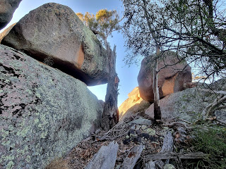
At the top a T-intersection sign indicates unmarked trails to the right and left. Since the vast majority of rocks were left, that’s where I, and many others before, trekked off to. It had shades of Girraween in Queensland about but these were more colourful and two were massive.


Probing along the narrow worn path I paused regularly for pics, so much was the variation and so many the angles. You’re not quite sure whether to take some leads or not but they all proved fruitful in the end and I was ecstatic with the results. Well over half an hour passed by before I got back to the intersection and took the other direction.


Here, there are occasional spots where the faintest of trails is visible but, basically, you’re on your own. Valley views were promised but, after about 20 minutes I hadn’t found any until I opted for a new direction. Moments later I came out upon a clear section featuring small rock outcrops laden with moss and lichen. The silence, as they say, was deafening. I found a comfy spot, sat down, and immersed myself in the panorama.


For accompaniment the cows way down on the farms decided it would be a good time to moo and, during the whole 15 minutes I sat there, they never shut up! The mist was slowly dissipating but the remnants looked lovely and added calm to the scene. By the time I left it was clear.


I got misplaced on the way back. Knew where I was heading but, since there are no paths on this less travelled side, it’s problematic which direction you should take. Thus I stumbled on another outcrop of granite before finding a way around it and eventually reaching the T-intersection once more.


The three hour mark was already broached as I started the descent, diverting to a significant outcrop before reaching the bottom, just as a group of noisy schoolchildren (are there any other types?) commenced the ascent on their day’s outing, probably not realising how lucky they are to be so close to a significant natural attraction and use it during school time.

After a well-earned cup of tea it was time to hit (literally) the potholes again!

Labels: , , , , , , ,